

MEXICO CITY.—The National Weather Serviceof the National Water Commissionissued the notice of its weather forecastfrom 06:00 a.m. on Thursday, October 30, 2025.
For today, the cold front number 11 will extend over the Yucatan Peninsulacausing heavy occasional rains in Oaxaca, Chiapas, Veracruz, Tabasco and Campeche; and isolated rains in areas of Yucatán and Quintana Roo.
Likewise, the “North” event with wind gusts of 50 to 60 km/h on the coasts of Tamaulipas, Veracruz, Tabasco, Campeche, Yucatán and Quintana Roo (decreasing during the day); In addition, waves of 2.0 to 3.0 meters high are expected on the coasts of Tamaulipas, Campeche, Yucatán and Quintana Roo.
😀Excellent Thursday! Start your day informed about the weather conditions for the next few hours in #Mexicoconsult our #VideoForecast morning. pic.twitter.com/V604gylqwh
— CONAGUA Climate (@conagua_clima) October 30, 2025
He “Mérida” Regional Hydrometeorological Centerof the Yucatan Peninsula Basin Organizationannounced his weather forecastvalid from 06:00 a.m. on Thursday 30th until 06:00 a.m. on Friday, October 31, 2025.
The passage of cold front number 11 will favor rains and storms in the Yucatan Peninsula. For its part, the continental polar air mass will cause a notable descent
of temperature in the region.
In the next 24 hours, partly cloudy to cloudy skies are expected, with
probability of isolated rains in Yucatán, strong occasional storms in Campeche and
intervals of showers in Quintana Roo due to the passage of cold front number 11.
The associated cold air mass will favor a warm and cool daytime environment to mild at night. It will also maintain a “North” event of 30 to 50 km/h, with gusts greater than 55 km/h in coastal areas.
Weather in Merida
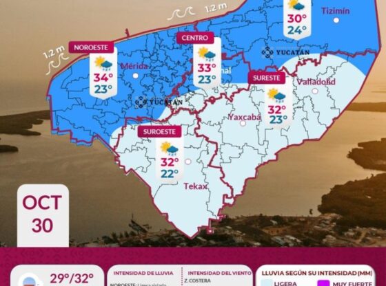
The temperature forecast for the city of Mérida is in the range of 26 to 28 °C as a maximum and 18 to 20 °C as a minimum. For the interior of the state, the maximum will be 28 to 39 °C in the south, minimum 14 to 16 °C in the south.
Current temperature of Merida
At 8:00 in the morning this Thursday, the temperature in Mérida was 26 °Celsius, with humidity of 57% and wind of 16 km/h.

The state coordination of Yucatan Civil Protection (Procivy) reported that, due to the influence of the cold air mass that accompanies cold front number 11, a warm environment will be recorded during the day and a cool to cold environment at night and dawn over the state of Yucatán.
Maximum temperatures are expected between 29° and 32°C in the interior of the state and 27° to 29°C in the coastal area.
The presence of isolated light rain in municipalities in the northeast, center and northwest and occasional drizzle in the southeast and southwest of the state are not ruled out.
Weather in Yucatan
Partly cloudy to cloudy skies, with a chance of isolated rain in the
northwest, north-center, northeast, east and south of the state. Warm atmosphere during the day and
cool to warm at night. Winds from the north-northwest of 30 to 50 km/h, with gusts
greater than 55 km/h on the coast.
Weather in Campeche
Partially cloudy to cloudy skies, with the probability of strong occasional storms in the south of the state, as well as isolated rains and intervals of showers in the north and center of the state, respectively. Warm atmosphere during the day and cool to warm at night. Winds from the north-northwest of 30 to 50 km/h, with gusts greater than 55 km/h on the coast.
Weather in Quintana Roo
Partially cloudy to cloudy skies, with a probability of intervals of showers with storms in the south of the state, as well as isolated rains in the north and center of the entity. Warm atmosphere during the day and cool to warm at night. Winds from the north-northwest of 30 to 50 km/h, with gusts greater than 55 km/h on the coast.
Hurricane Melissa in the Atlantic Ocean

The National Hurricane Center (NHC) issued its warning about Hurricane Melissa, in the waters of the Atlantic Ocean.
According to the report, at 08:00 am EDT (06:00 am Central Mexico Time), the center of Hurricane Melissa was located by an Air Force Hurricane Hunter aircraft near latitude 26.8 North, longitude 72.7 West. Melissa is moving north-northeast near 33 km/h, and the hurricane is expected to continue accelerating toward the northeast over the next two days.
On the forecast track, the center of Melissa is expected to pass northwest of Bermuda late tonight.

Maximum sustained winds are near 165 km/h with stronger gusts. Little change in strength is expected today, and a weakening trend is likely to begin on Friday.
Hurricane-force winds extend outward up to 95 km from the center and tropical storm-force winds extend outward up to 315 km.
The minimum central pressure reported by Hurricane Hunters is 965 mb (28.50 inches).
CDMX Climate

The National Meteorological Service (SMN), in its general forecast, foresees for the Valley of Mexico: In the morning, sky with scattered clouds, cold atmosphere in the region, being very cold (-5 to 0 °C) and with possible frost in high areas of the Valley of Mexico, in addition to fog banks. During the afternoon, mild weather, partially cloudy skies in most of the Valley of Mexico and no rain in Mexico City, and partly cloudy skies with the probability of isolated rains in the southwest of the State of Mexico. The minimum temperature in Mexico City will be 5 to 7 °C and the maximum 22 to 24 °C. For Toluca, Edo. Mex., minimum temperature of 4 to 6 °C and maximum of 19 to 21 °C is expected. Wind from the north and northeast of 10 to 20 km/h in the region; with gusts of 35 to 50 km/h in areas of the State of Mexico, and with gusts of less than 35 km/h in areas of Mexico City.
How will the weather be?

The SMN, in its forecast by region, anticipates for the Gulf of Mexico: During the day, partly cloudy to cloudy skies, without rain in Tamaulipas. In the morning, fog banks in high areas; cold environment and possible frost in mountainous areas of Veracruz, and cold to cool in the rest of the region. Possibility of morning rains and showers in Tabasco and southern Veracruz (Los Tuxtlas and Olmeca regions). During the afternoon, temperate atmosphere; heavy occasional rains with electric shocks in Veracruz (Olmeca region) and Tabasco (north, east and west), which could be accompanied by strong gusts of wind and cause an increase in the levels of rivers and streams, landslides, flooding, flooding and reduced visibility.; In addition, showers with possible electric shocks are expected in Veracruz (Capital, Las Montañas and Los Tuxtlas regions). A “North” event of 20 to 35 km/h with gusts of 50 to 60 km/h and waves of 2.5 to 3.5 meters high (decreasing throughout the day) is forecast on the coasts of Tamaulipas, Veracruz and Tabasco. Waves of 2.0 to 3.0 meters high on the coast of Tamaulipas.
While, for the Yucatan Peninsula forecast: During the day, partly cloudy to cloudy skies. In the morning, banks of fog or mist; temperate environment. Possibility of isolated morning rains in western Campeche. During the afternoon, warm atmosphere; heavy occasional rains with electric shocks in Campeche (west), which could be accompanied by strong gusts of wind and cause local flooding, flooding and reduced visibility.; Likewise, isolated rains are expected in areas of Yucatán and Quintana Roo. “North” event of 20 to 35 km/h is forecast in the region, with gusts of 50 to 60 km/h in areas of Campeche, Yucatán and Quintana Roo (decreasing starting tonight). Waves of 2.0 to 3.0 meters high (decreasing throughout the day) on the coasts of Campeche, Yucatán and Quintana Roo.