

MEXICO CITY.—The National Weather Serviceof the National Water Commissionissued the notice of its weather forecastfrom 06:00 a.m. on Thursday, November 20, 2025.
This day, low pressure channels in the interior and southeast of the country, together with the moisture ingress coming from the Pacific Ocean, Gulf of Mexico and Caribbean Sea, will generate rains and showers in the west, center, east, south and southeast of Mexico, including the Yucatan Peninsula.
We share the weather status for the next few hours. pic.twitter.com/a2SBewBrcY
— Yucatán Civil Protection (@procivy) November 20, 2025
He “Mérida” Regional Hydrometeorological Centerof the National Weather Servicereleased the report on the weather forecastvalid from 06:00 a.m. on Thursday the 20th to 06:00 a.m. on Friday, November 21, 2025.
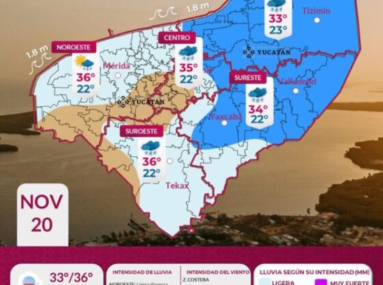
The document indicates that, in the next 24 hours, in Yucatán it is expected partly cloudy sky to cloudy, with a chance of shower intervals in the northwest, north-central, northeast, east and south of the state. Warm to hot environment during the day and warm at night.
Partially cloudy to cloudy skies are expected, with the probability of intervals of showers in Yucatán, Campeche and Quintana Roo due to the humidity associated with a trough, which will be located over the Gulf of Mexico. Warm to hot environment during the day and warm at night. Winds from the east-southeast of 10 to 20 km/h, with gusts greater than 40 km/h.
Weather in Merida
The temperature forecast for the city of Mérida is in the range of 33 to 35 °C as a maximum and 20 to 22 °C as a minimum. For the interior of the state, the maximum will be 33 to 35 °C in the south and North-Central, minimum 19 to 21 °C in the east.
Current temperature of Merida
At 7 in the morning this Thursday, the temperature in Mérida was 24 °Celsius, with humidity of 91% and wind of 6 km/h.

The state coordination of Yucatan Civil Protection (Procivy) reported that the entry of tropical maritime air from the Caribbean Sea and the Gulf of Mexico will favor the presence of moderate rain in the afternoon in the northeast and southeast of Yucatán and light rain with showers at night in the rest of the state.

In his social network account “X”, formerly Twitter, Juan Antonio Palma Solísmeteorologist at the meteorological agency Meteored Méxicoannounced that a trough will lead to some rain this Thursday.
Palma Solís predicts a probability of rain and some isolated storms due to a trough in the Yucatán Peninsula region, could be recorded this day.
CDMX Climate

The National Meteorological Service (SMN), in its general forecast, foresees for the Valley of Mexico: In the morning, partially cloudy skies, cold to cool atmosphere in the region, and very cold atmosphere with frost in high areas of the Valley of Mexico. In the afternoon, warm atmosphere, partly cloudy sky with isolated rains in Mexico City and the State of Mexico. The minimum temperature in Mexico City will be 6 to 8 °C and the maximum 25 to 27 °C. For Toluca, Edo. Mex., a minimum temperature of 1 to 3 °C and a maximum of 21 to 23 °C is expected. Wind direction variable from 10 to 20 km/h with gusts of up to 35 km/h.
How will the weather be?

The SMN, in its forecast by region, anticipates for the Gulf of Mexico: Partly cloudy to cloudy skies during the day, with occasional heavy rains and possible electrical shocks in Tamaulipas (northwest); accompanied by electric shocks, which could reduce visibility on road sections, cause flooding, landslides and flooding, and increase the levels of rivers and streams.. Showers with possible electric shocks in Veracruz (Olmeca region) and isolated rains in Tabasco. In the morning, cold atmosphere with frost in high areas of Veracruz, and cool to temperate in the rest of the region. Fog banks. During the afternoon, warm to hot atmosphere. Wind from the south and southeast at 30 to 40 km/h with gusts of 50 to 70 km/h in Tamaulipas, and gusts of 30 to 50 km/h in Veracruz and Tabasco.
While, for the Yucatan Peninsula forecast: Partly cloudy to cloudy skies with showers and possible electrical shocks in Campeche, Yucatán and Quintana Roo. In the morning, temperate environment; in the afternoon warm to hot atmosphere. Wind from the east and northeast of 10 to 20 km/h with gusts of 30 to 50 km/h in Campeche and Yucatán, and gusts of up to 35 km/h in Quintana Roo.