
MEXICO CITY.—The National Weather Serviceof the National Water Commissionissued the notice of its weather forecastfrom 06:00 a.m. on Sunday, November 9, 2025.
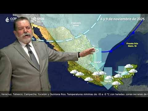
For today, the cold front number 13 It will move rapidly over the north, northeast and east of the country, in interaction with a low pressure channel over the southeast of Mexico, will cause heavy rains in the Yucatan Peninsula.
It is expected “North” event with gusts of 40 to 50 km/h on the coasts of Tabasco and Campeche; as well as strong to very strong winds in northern and central states of Mexico.
Finally, in the rest of the national territory, partly cloudy skies will predominate with no chance of rain.

He “Mérida” Regional Hydrometeorological Centerof the Yucatan Peninsula Basin Organizationannounced its weather forecast, valid from 06:00 a.m. on Sunday the 9th until 06:00 a.m. on Monday, November 10, 2025.
The report indicates that, this morning, partially cloudy skies will predominate, some fog will occur in the northern area of Campeche, southwest and south of Yucatán, as well as in the center of Quintana Roo.
In the next 24 hours, an extensive trough induced by the proximity of the new cold front number 13 over the Yucatan Peninsula, will be leaving heavy rains in the east, center and south of Yucatán, center and south of Campeche, as well as in the center and south of Quintana Roo.
The dominant winds will be from the southeast, changing in the afternoon to the northwest at 15 to 20 km/h with gusts of 40 km/h in coastal areas. In addition, the atmosphere will become hot to very hot during the day and warm at dawn.
Weather in Yucatan
Partially cloudy skies with heavy rains in the east, center and south of the state.
Hot to very hot environment during the day and warm at dawn. Southeast wind
changing in the afternoon to the northwest from 15 to 20 with gusts of 40 km/h in coastal areas.
Weather in Campeche
Partially cloudy skies and heavy rains in the southern and central areas of the state.
Hot to very hot environment during the day and warm at dawn. Southeast wind
changing in the afternoon to the northwest at 15 to 20 km/h with gusts of 40 km/h towards the coast.
Weather in Quintana Roo
Partly cloudy skies, with a probability of heavy occasional rains in the center and south of the state. Hot environment during the day and warm at dawn. Wind of the
east-southeast of 15 to 20 km/h, with gusts of 40 km/h in coastal areas.

The state coordination of Yucatan Civil Protection (Procivy), reported that the entry of tropical maritime air and the establishment of a trough will favor the presence of moderate and strong rain over the state of Yucatán, registering after noon in the northeastern municipalities of the state and, after 2:00 p.m., in the center, southeast, southwest and northwest, including the municipality of Mérida.
At night, the proximity of cold front number 13 will cause rain mainly in the coastal and surrounding municipalities.
The maximum temperature will range between 33° and 37°C in the interior of the state and from 29° to 31°C in the coastal area.
The wind will be from the southeast in the morning, changing from the north in the afternoon.

In his social network account “X”, formerly Twitter, Juan Antonio Palma Solísmeteorologist at the meteorological agency Meteored Méxicoreported that, due to the rapid advance of cold front number 13, which he calls: “Che chén”, through the Gulf of Mexico it will induce a trough over the Yucatan Peninsula that, in interaction with another trough extended over Central America, will favor rains in several areas of the region.
CDMX Climate

The National Meteorological Service (SMN), in its general forecast, foresees for the Valley of Mexico: In the morning, clear sky and mist; cold environment, being very cold with possible frost in high areas. During the afternoon, mild to warm atmosphere and partially cloudy skies, without rain in Mexico City. The minimum temperature in Mexico City will be 7 to 9 °C and the maximum 22 to 24 °C. For Toluca, Edo. Mex., minimum temperature of 2 to 4 °C and maximum of 19 to 21 °C is expected. Towards the evening, wind of 10 to 20 km/h with gusts of 35 to 50 km/h and a drop in temperatures, with the probability of isolated rains in areas of the State of Mexico.
How will the weather be?

The SMN, in its forecast by region, anticipates for the Gulf of Mexico: During the day, partly cloudy to cloudy skies. In the morning, cool to temperate atmosphere in Tamaulipas and Veracruz, being cold with frost in the mountainous area of Veracruz. During the afternoon, warm atmosphere; intense occasional rains, electric shocks in Veracruz (Papaloapan, Los Tuxtlas and Olmeca regions) and Tabasco (west); as well as very strong occasional rains with electric shocks in Veracruz (Huasteca Baja, Totonaca and Nautla regions); and heavy occasional rains with possible electric shocks in Tamaulipas (South and Mante regions) and Veracruz (Huasteca Alta, Capital, Sotavento and Las Montañas regions); These rains could cause an increase in the levels of rivers and streams, landslides, flooding, flooding and reduced visibility.. “North” event from 40 to 55 km/h with gusts of 70 to 90 km/h on the coasts of Tamaulipas and Veracruz; and with wind gusts of 40 to 50 km/h in Tabasco. Waves of 2.0 to 3.0 meters high are expected on the coasts of Tamaulipas and Veracruz.
While, for the Yucatan Peninsula forecast: During the day, partly cloudy to cloudy skies. In the morning, warm atmosphere. During the afternoon, hot atmosphere; heavy occasional rains with electric shocks in Campeche (southwest), Yucatán (east) and Quintana Roo (coast and south); These rains could cause local flooding, flooding and reduced visibility.. North Event from 20 to 30 km/h on the peninsula, with gusts of 40 to 50 km/h during this night and early Monday morning in Campeche; and gusts of 30 km/h in Yucatán and Quintana Roo.