
Published On 4/11/2025
|
Last update: 15:44 (Mecca time)
The crimes that occurred in the Sudanese city of El Fasher witnessed widespread attention on social media platforms, where satellite images sparked great interaction, as clear evidence of the violations the city was subjected to in the absence of field press coverage.
However, this widespread interaction was accompanied by a wave of digital misinformation, as satellite images were circulated that their publishers claimed were linked to the recent events in El Fasher.
Read also
list of 2 itemsend of list
Some accounts were published image of satellites showing gatherings, which the publishers claimed were dead bodies, with captions such as “Scary images from satellites in Sudan” and “Talk about genocide.”
this is the most disturbing google earth image ever…
SPEAK ON THE GENOCIDE OF SUDAN pic.twitter.com/3saDBXdVJ7
— eurovision season STILL on crack 🇵🇸🇺🇦🇦🇲🇸🇩 (@undsupermegahot) November 3, 2025
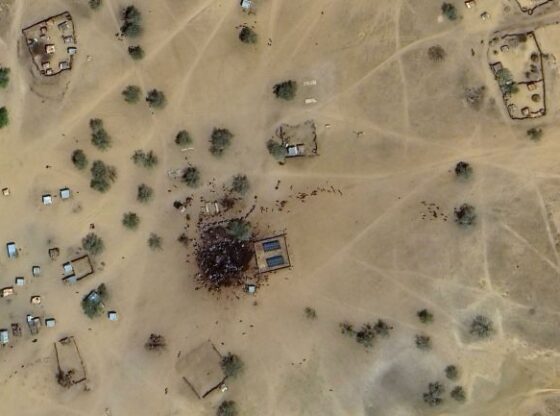
The Al Jazeera Verification team conducted a review of the satellite image via Google Earth Pro, where it was found that the image is old and dates back to the east of the Abu Matariq area in East Darfur state.
Our team’s matching of the area’s topography and visible elements such as the water well and solar panels revealed that what is in the picture are not bodies, but a water well and a solar-powered station around which a large number of people and livestock are gathered.
According to the Google Earth photo archive, the photo was taken in March 2024, that is, more than a year and a half before the recent events in El Fasher.
Accounts on the platforms also promoted another photo taken by satellite – within the same posts of burning vehicles – which its publishers claimed showed the great destruction in the city of El Fasher following the violent attacks of the Rapid Support Forces.
Our team examined the image and found that it dates back to the Jabal Awliya area, south of Khartoum, and documents the moment the Sudanese army destroyed a convoy of rapid support vehicles in March 2025 while it was trying to withdraw from the city.
🟩 The Rapid Support militia escaped across the Jabal Awliya Bridge, south of Khartoum.#Sudan_War_Updates pic.twitter.com/5HJcNSEoEH
— Sudan War Updates (@sudan_war) March 26, 2025
Examining the archive from Google Earth maps revealed that the image was taken last May, and has nothing to do with the recent events in El Fasher.

The city of El Fasher, the capital of North Darfur State, witnessed grave violations and mass liquidation operations against civilians, documented by video clips published by members of the Rapid Support themselves, in addition to… Recent satellite images It showed extensive damage within the city.
Many international and human rights organizations and countries condemned these crimes, describing them as “the most brutal” since the outbreak of war in Sudan in April 2023.
Reports of the United Nations and other organizations indicate that the war has claimed the lives of more than 20,000 people and caused the displacement of more than 15 million civilians inside and outside Sudan, making it one of the worst humanitarian crises in the world.